The Turn Comes Before the Sign: Timing a Wayfinding Cue
Wayfinding cue timing helps you spot whether a direction arrives too late, so you can identify what information a newcomer needs before a city turn.
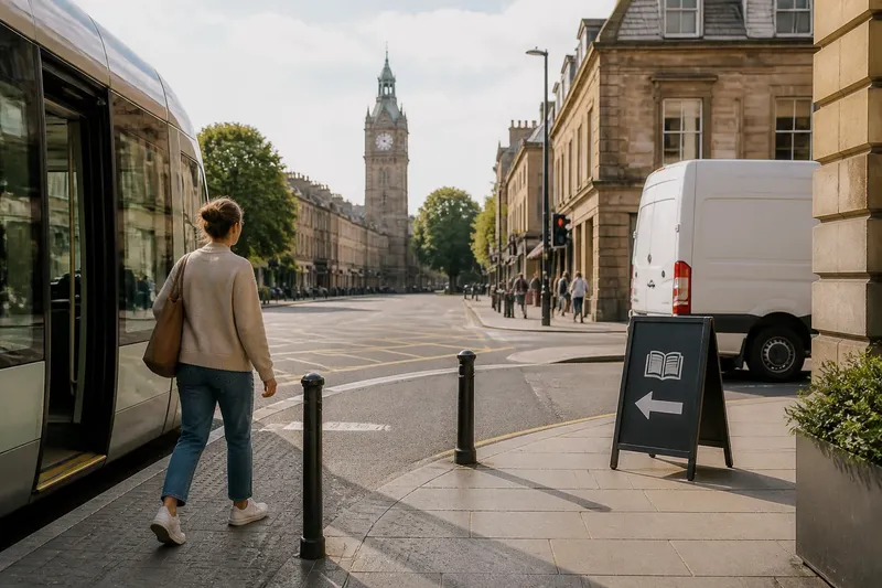
A visitor steps off a tram, checks the street ahead and reaches a junction before finding the library sign. Wayfinding cue timing is the question here: does useful information arrive while it can still guide the choice, or only after the route has chosen for the walker?
Rather than treating every corner as a sign-placement problem, look at what the street reveals in sequence. A junction can be legible through a visible landmark, a distinctive crossing or a clear relationship between the approach and the destination; a sign is only one part of that picture.
What does the street tell a walker before a turn?
On an unfamiliar route, people assemble clues rather than read a single instruction. They may recognise a church tower beyond the junction, follow a line of paving towards a crossing, or use the shape of a square to understand which street continues through it.
That makes timing less like ringing a doorbell and more like reading a map folded across the right street: the useful detail must be available when the route begins to make sense. A cue placed early but detached from the feature it describes can be as unhelpful as one that appears late.
Separate the clues into three kinds: orientation, which helps someone understand where they are; route information, which shows a connection or direction; and confirmation, which indicates that the chosen path still makes sense. One object may serve more than one purpose, but it need not do all three.
How can a route be read as a sequence of clues?
Imagine a hypothetical visitor walking from a tram stop to a neighbourhood library. The library entrance is not visible from the approach, but a clock tower stands beyond the junction, and a pavement sign names the library on the near side. The question is not simply when the sign appears; it is whether the tower, street layout and sign together make the intended route understandable.
At the approach, the visitor can use the tower as an orientation cue. Near the junction, the sign can connect the destination name to the left-hand street. After the turn, a library name or recognisable entrance can confirm the route. If the sign is hidden by a delivery van, the tower may still orient the visitor, but it does not necessarily identify which street leads to the library.
This distinction helps describe the problem precisely. “The turn is hard to read” invites a different response from “the destination name is hidden” or “there is no confirmation after the crossing”. Each points to a different missing relationship between place, route and information.
What should you record when a route feels unclear?
Make a brief route note that records the street’s clues, not just the position of signs. For each point where the route changes character, note what a newcomer can see, what each visible cue seems to refer to, and what remains uncertain.
- Visible destination: If the entrance or destination name can be seen from the approach, note what connects it to the route; if it cannot, check whether another cue identifies the destination before the junction.
- Landmark relationship: If a landmark is visible, note whether it sits beyond or beside the intended route; if its relationship is unclear, do not treat it as a substitute for directional information.
- Street shape: If paving, buildings or the alignment of the road make one route appear continuous, note which way that continuity leads; if several streets look equally plausible, identify where extra orientation is needed.
- Sign meaning: If a sign names a place and its arrow clearly corresponds to one street, record that connection; if wording and arrow seem to point to different things, flag interpretation rather than timing.
- Crossing choice: If the route requires a particular crossing or pavement, note whether the approach makes that choice apparent; if not, identify the missing information before the walker reaches the kerb.
- After-turn confirmation: If a landmark, sign or destination name confirms the route after the turn, record what it is; if no confirmation is visible, note where a newcomer may begin to doubt the choice.
- Changing views: If a tree, parked vehicle or shop queue obscures a useful clue, record what disappears and from which approach; if the obstruction is temporary, distinguish it from a permanent gap in the street’s information.
These checks help separate a missing clue from a badly timed one. If the right information is present but points ambiguously, moving it earlier will preserve the ambiguity. If the route is clear until a crossing and then loses its identity, an additional sign at the start may not solve the problem.
How can the hypothetical library route be worked through?
Say the starting information is this: the visitor begins at the tram stop; the library is left at the next junction; a clock tower is visible beyond that junction; the library name appears on a sign beside the corner; and a delivery van temporarily blocks that sign from the tram-stop approach. The decision is whether the problem is simply late sign visibility or a broader lack of route connection.
- Record the tower as an orientation clue, because it is visible before the junction. Do not assume it identifies the library street; it only gives the visitor a feature to locate.
- Record the pavement sign as the route clue, because it names the library and sits by the left-hand street. Since the van hides it on approach, the sign cannot currently connect the destination to the turn for someone arriving from the tram stop.
- Check the street alignment and crossing. If both leave the left turn visually distinct, the visitor may understand the choice once the sign appears; if the junction offers several plausible routes, the missing sign matters more.
- Look beyond the corner for confirmation. If the library name or entrance becomes visible after turning, the visitor can check the choice; if not, the route remains dependent on an obscured corner sign.
- State the resulting trade-off: clearing or changing the view of the existing sign may restore the destination-to-street connection, while an earlier cue could help if the junction itself is difficult to interpret. The tower alone is not enough to choose between those actions.
The expected observable result of addressing the view is that the visitor can connect “library” with the left-hand street before committing to it. If the junction still looks ambiguous despite that connection, the remaining issue is the route’s structure or supporting information, not merely the sign’s timing.
Which questions help distinguish a late cue from a confusing route?
When is a landmark useful for wayfinding?
A landmark helps when it is distinctive, visible from the approach and clearly related to the destination or route. If it is merely prominent but unrelated, it can orient a visitor without telling them which way to go.
Does a sign need to appear before every junction?
No. At a simple junction, street layout and a visible destination may make the route clear without another panel. Add or adjust information where a newcomer cannot reliably connect the available clues to the intended route.
What if the direction is clear but the route still feels uncertain?
Look for a break after the turn: an unmarked crossing, a sudden change in pavement or a lack of confirmation can make a correct choice feel doubtful. The useful response may be a cue beyond the junction rather than an earlier one.
Should temporary obstructions change the route assessment?
Yes, but record them separately from permanent features. A delivery vehicle that regularly blocks a sign may call for a more visible position, while a brief obstruction suggests checking whether other clues still make the route intelligible.
What makes a route legible beyond the sign?
Wayfinding cue timing is easiest to assess when the whole sequence is considered: what orients a person, what links the destination to a route, and what confirms the choice afterwards. That view avoids treating every hesitation as evidence that another sign is needed.
For the hypothetical library route, the note points to a specific issue: the clock tower helps with orientation, while the blocked pavement sign carries the connection to the left-hand street. The next discussion can focus on restoring that connection and checking whether the junction remains ambiguous, rather than placing information wherever a walker happens to pause.
When you review wayfinding cue timing elsewhere, keep the route note focused on relationships between clues. A street becomes easier to read when its landmarks, crossings and public information support one another; even a clear sign has limited use if the surrounding place gives it nothing intelligible to point towards.